Presented at SAGEEP 2015, Austin, Texas
For a PDF of this paper click here
Abstract
VTEM helicopter time-domain EM survey results over the Brandon Channel and Assiniboine Delta aquifers, near Brandon, Manitoba, have been studied using unconstrained layered earth modeling. The resistive sand and gravel layers are distinguished from the more conductive shale basement and reveal localized thickening from blind gravel channels cut into its floor. They further distinguish a lower aquifer separated by a conductive clay layer from shallow sands of the Assiniboine Alluvial aquifer and the Assiniboine Delta Aquifer. The Brandon Channel aquifer is delineated, to the northwest and east of the city where it splits into a main south channel and smaller north channel. The western extent of Assiniboine Alluvial aquifer is defined and evidence for the Pierson Valley aquifer extending west from Brandon is also indicated.
Introduction
Buried valley aquifers are important sources of groundwater supply in the Prairie Provinces of Canada, consisting of permeable sand and gravel deposits in eroded bedrock valleys. In Manitoba buried valley aquifers have been difficult to define because they are often partially eroded, have complex lithology and are hidden amongst other shallow sand and gravel aquifers within thick glacial overburden.
Recent investigations of the Spiritwood Valley aquifer, which extends into southern Manitoba from North Dakota, by the Geological Survey of Canada and other workers, have demonstrated the value of helicopter time domain electromagnetic (HTEM) surveys in aquifer mapping and characterization (Oldenborger, 2010a; 2010b; Oldenborger et al., 2010; 2011; 2012; 2013; Sapia et al., 2012; 2013; 2014; 2015; Legault et al., 2012; 2013; Prikhodko et al., 2013). In February, 2013, the Department Manitoba Conservation and Water Stewardship commissioned a similar HTEM survey of a region surrounding the city of Brandon to map the Brandon Channel aquifer (Fiset et al., 2013). While the Brandon Channel aquifer was known to exist in the area where it is an important source of water for local industries, the boundaries of the aquifer, its complex internal structure and water bearing zones remained enigmatic.
HTEM Survey Results
The helicopter time-domain EM survey used in Brandon was the Full Waveform VTEM system (Legault et al., 2012; 2013) and horizontal magnetic gradiometer. The block was flown in a southwest to northeast direction (N 15° E azimuth) traverse line spacing of 400 metres; tie lines were flown perpendicular to the traverse lines at a spacing of 5000 metres (Figure 1). As shown the survey extended along the Assiniboine river valley with survey lines clipped to avoid populated areas of the city of Brandon to the west and the town of Shilo to the east. A total of 645 line-kilometres of geophysical data were acquired during the survey over an area of 244 square kilometres. Figure 2 presents the VTEM EM decay time-constant (TAU) that highlights conductivity highs (warm colours, slow decays) and conductivity lows (cool colours, fast decays) that relate to the subsurface geology.
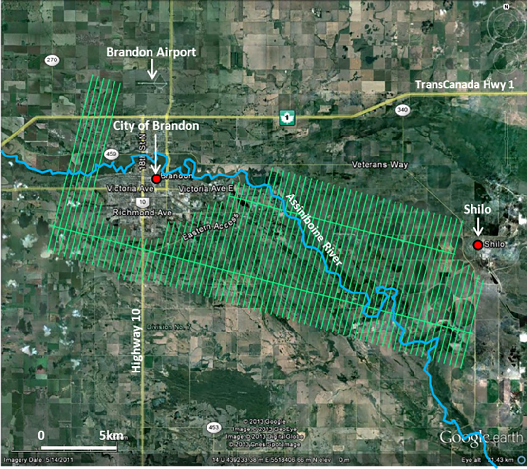
Figure 1: Brandon survey area and VTEM flight lines, in Google earth.
Highlighted are resistive lineaments that are interpreted to represent buried gravel valleys that have been eroded into the more conductive basement shale bedrock, forming channels filled with more resistive coarse-grained material. The Brandon Channel aquifer is observed to be comprised of two valleys that may or may not be connected to each other, and to the Pierson Valley aquifer to the southwest.
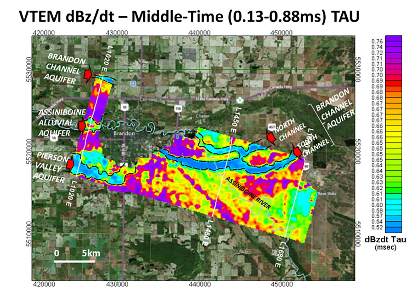
Figure 2: VTEM dBz/dt middle-time EM decay time-constant (TAU), with interpreted hydrogeologic features and locations of LEI sections shown in Figure 3.
1D Layered-Earth Inversions
The VTEM dBz/dt EM data were converted to their equivalent cross-sectional resistivity-depth distribution using the Airbeo one-dimensional (1D) layered-earth inversion (LEI) program by CSIRO (Chen and Raiche, 1998) that models the EM decay response using discrete layer thicknesses and resistivities. The EM soundings were decimated to ~12m intervals. All the off-time decay channels from 0.031 to 8.083 msec. were fit to the modelled response from 4-layer model. No constraints on layer-resistivities or thicknesses were applied and the initial 4-layer starting model was the same for all soundings. Pseudo-2D resistivity sections were then constructed for all 76 lines using the recovered 1D resistivity models. Figure 3 presents three representative LEI cross-sections from the western (L1020), central (L1450) and eastern (L1680) survey areas.
The sections in Figure 3 reveal a conductive basement (<10 ohm-m) that is distinguished from the more resistive (>10-500 Ω-m) overburden. The overburden sequence is observed to be from 30 to 100 m thick and appears to be composed of at least three layers: 1) The resistive (>100 Ω-m) surficial layer that is less than 50 m thick is interpreted as glacial-fluvial sands and gravels that are observed across the survey area (Matile and Keller, 2004). 2) The intermediate thin conductive layer (~10 Ω-m) approximately 10 to 30 m thick suggests silt- or clay-rich material, possibly a glacio-lacustrine clay-plain. 3) The lower resistive layer (>100 Ω-m) has variable thickness from <10m to >100m in accordance with bedrock topography and is interpreted as coarse-grained fill deposited in bedrock valleys. The interpreted sedimentary sequence corresponds to a hydrogeological model of deep buried valley aquifers separated from a surficial upper aquifer by an intermediate clay aquitard.
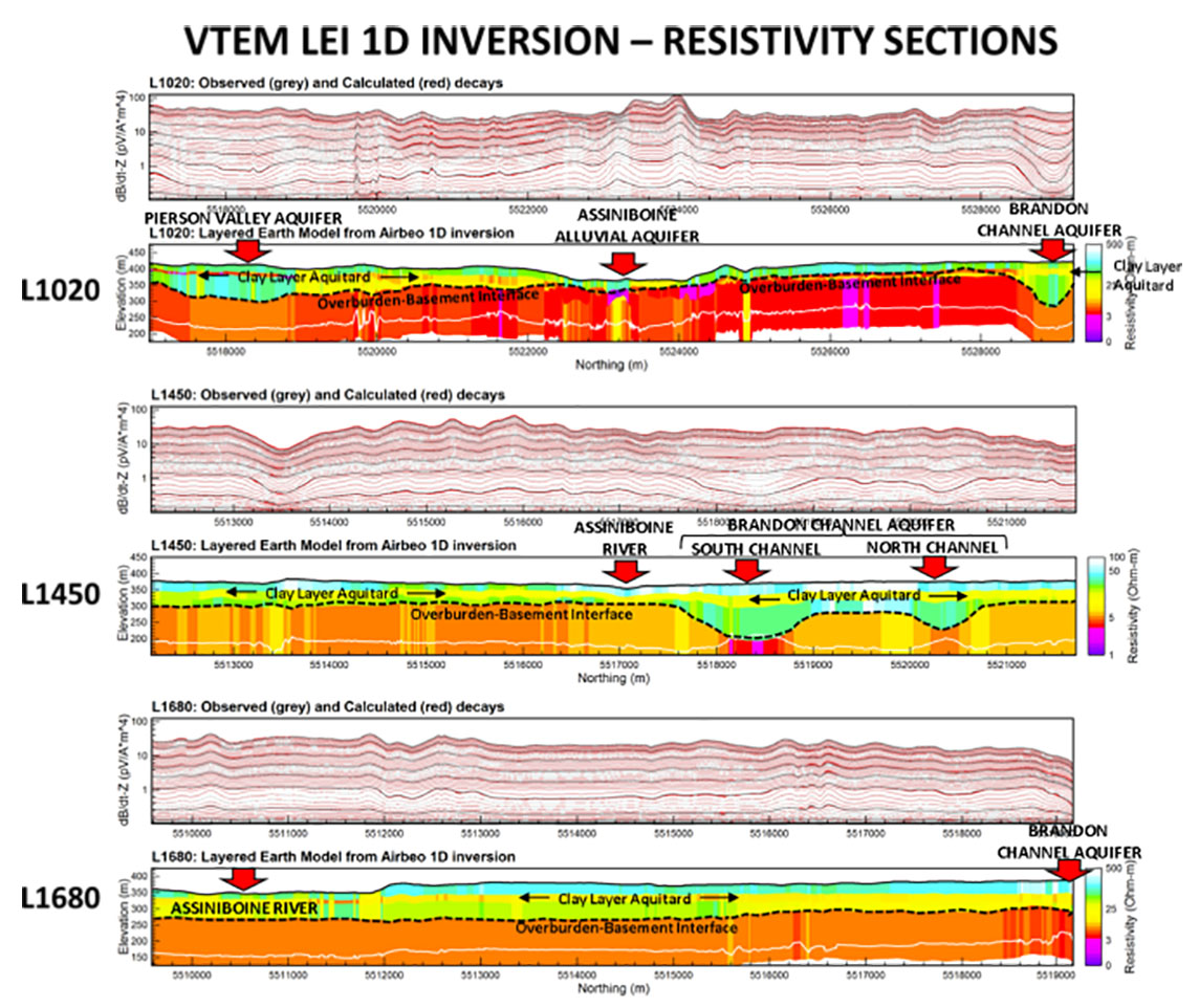
Figure 3: VTEM unconstrained 1D Layered Earth Inversion (LEI) resistivity cross-sections for selected lines (see locations in Figure 2).
Figure 4 presents the bedrock topography over survey area estimated as the elevation of the contact with the bottom conductive layer in the 1D inversion results. The Brandon Channel aquifer is identified in the northwest and observed to split into two channels (north & south) in the main survey area. The Assiniboine Alluvial aquifer is only visible to the west of the survey area and there is evidence of the Pierson Valley aquifer which extends west of Brandon.
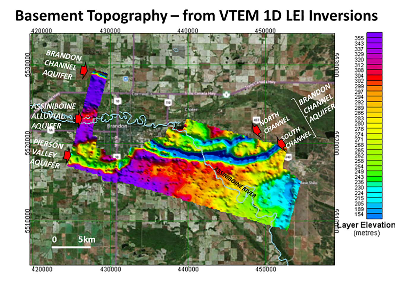
Figure 4: Basement topography contours from VTEM 1D Layered Earth (LEI) Inversions (LEI), showing interpreted hydrogeologic features.
Conclusions
VTEM helicopter time-domain EM survey results near Brandon, Manitoba have been studied using unconstrained layered earth inversion. Resistivity models reveal the boundaries of the Brandon Channel aquifer including two separate valleys (North and South Channels) cut into its floor. The models further distinguish a lower aquifer separated by a conductive clay layer from shallow sands of the Assiniboine Alluvial aquifer and the Assiniboine Delta aquifer. Evidence for the Pierson Valley aquifer extending west from Brandon is also indicated.
Acknowledgements
The authors wish to thank the Manitoba Conservation and Water Stewardship Department, Government of Manitoba, for allowing us to show these results.
References
Chen, J., and Raiche, A., 1998, Inverting AEM data using a damped eigenparameter method: Exploration Geophysics, 29, 128–132.
Fiset, N., Orta, M., Prikhodko, A., and Plastow, G., 2013, Report on a helicopter-borne Versatile time-domain electromagnetic (VTEMPLUS) and horizontal magnetic gradiometer geophysical survey, Brandon Channel Aquifer, Brandon, Manitoba, for Government of Manitoba, Department of Conservation and Water Stewardship, Geotech Ltd.: Internal report, 106 p.
Legault, J. M., Prikhodko, A., Dodds, D.J., Macnae, J.C., and Oldenborger, G.A., 2012, Results of recent VTEM helicopter system development testing over the Spiritwood Valley aquifer, Manitoba: 25TH SAGEEP Symposium on the Application of Geophysics to Engineering and Environmental Problems, Expanded Abstract, 17 p.
Legault, J. M., Prikhodko, A., Eadie, T., Oldenborger, G.A., Sapia, V., Viezzoli, A., Gloaguen, E., Smith, B.D., and Best, M.E., 2013, Recent AEM case study examples using a full waveform time-domain system for near-surface applications: Geoconvention 2013, Expanded Abstract, 5 p.
Matile, G.L.D., and Keller, G.R., 2004, Surficial geology of the Brandon map sheet (NTS 62G), Manitoba: Manitoba Geological Survey, SG-62G. Scale 1:250 000.
Oldenborger, G.A, 2010a. AeroTEM III Survey, Spiritwood Valley, Manitoba, parts of NTS 62G/3, 62G/4, Manitoba: Geological Survey of Canada, Open file 6663. Scale 1:50 000, 4 maps.
Oldenborger, G.A, 2010b. AeroTEM III Survey, Spiritwood Valley, Manitoba, parts of NTS 62G/3, 62G/4, 62G/5, 62G/6, Manitoba: Geological Survey of Canada, Open file 6664. Scale 1:50 000, 4 maps.
Oldenborger, G.A., Pugin, A.J.-M., Hinton, M.J., Pullan, S.E., Russell, H.A.J., and Sharpe, D.R., 2010, Airborne time-domain electromagnetic data for mapping and characterization of the Spiritwood Valley aquifer: Manitoba, Geological Survey of Canada, Current Research 2010-11, 13p.
Oldenborger, G.A., Pugin, A.J.–M., and Pullan, S.E., 2011, Buried valley imaging using 3-C seismic reflection, electrical resistivity and AEM surveys: GeoHydro 2011: Joint meeting of the Canadian Quaternary Association and the Canadian Chapter of the International Association of Hydrogeologists, Expanded Abstract, 6 p.
Oldenborger, G.A., Pugin, A.J.–M., and Pullan, S.E, 2012, Airborne time-domain electromagnetics for three-dimensional mapping and characterization of the Spiritwood Valley Aquifer: 25TH SAGEEP Symposium on the Application of Geophysics to Engineering and Environmental Problems, Expanded Abstract, 5 p.
Oldenborger G.A., Pugin, A.J.-M., and Pullan, S.E., 2013, Airborne time-domain electromagnetics, electrical resistivity and seismic reflection for regional three-dimensional mapping and characterization of the Spiritwood Valley Aquifer, Manitoba, Canada: Near Surface Geophysics, 11, 63–74.
Prikhodko, A., Legault, J.M., Kwan, K., Eadie, T., Oldenborger, G.A., Sapia, V., Viezzoli, A., Gloaguen, E., Smith, B.D., and Best, M.E., 2013, Recent AEM case study examples using a full waveform time-domain system for near-surface applications: 26TH SAGEEP Symposium on the Application of Geophysics to Engineering and Environmental Problems, Expanded Abstract, 10 p.
Sapia, V., Viezzoli, A., and Oldenborger, G.A., 2012, Investigating the role of constraints from seismic, resistivity and boreholes in the inversion of airborne EM data: Geoconvention 2012, Expanded Abstract, 3 p.
Sapia, V., Viezzoli, A., Oldenborger, G.A. and Jørgensen, F. 2013. Advanced processing and inversion of two AEM datasets for 3D geological modelling: The case study of Spiritwood Valley Aquifer. Geoconvention 2013, Expanded Abstract, 5 p.
Sapia, V., Oldenborger, G.A., Viezzoli, A., and Marchetti, M., 2014, Incorporating ancillary data into the inversion of airborne time-domain electromagnetic data for hydrogeological applications: Journal of Applied Geophysics, 104, 35–43.
Sapia, V., Viezzoli, A., and Oldenborger, G., 2015, Joining multiple AEM datasets to improve accuracy, cross calibration and derived products: The Spiritwood VTEM and AeroTEM case study. Near Surface Geophysics, 13, 61–72.