For a PDF of this paper click here
Introduction
Mineral explorations require high-resolution aeromagnetic data for geological mapping and structural interpretations. Since direct detection of mineral deposits, for example gold, is not always possible, we have to rely on indirect detection of mineralized bodies by investigating the host rocks (geological mapping), traps, faults, shear zones (structures). The aeromagnetic data collected from the Tri-axial Gradiometer (HeliGrad) system meet those exploration needs.
Many of the advanced magnetic data interpretation techniques, such as the Euler Deconvolution (Reid et al, 1996), Source Parameter Imaging (Thurston and Smith, 1997), use magnetic gradients. Measured magnetic gradients do not depend on the Earth’s magnetic field and are not affected by diurnal variations. Therefore, the calculated magnetic grids can be made more accurate using the measured gradients (Hardwick, 1999 and Reford, 2004). Complex magnetic 2D or 3D inverse models can be better constrained and more easily resolved with gradient data. The magnetic data between the survey lines can be better extrapolated using the measured cross-line gradients.
The HeliGrad system (Figure 1a) is a helicopter-borne tri-axial magnetic gradiometer platform which collects full magnetic gradient data in three principle directions, in-line, cross-line and vertical (Figure 1b). The system uses a GPS receiver and a Gyro Inclinometer to provide positions and orientations of the gradiometers in real-time. Magnetic data distortions due to deviations from the horizontal, in-line and cross-line vertical planes of the gradiometers are corrected during post processing, therefore improving the quality of the final delivered magnetic data. The correction methods will be discussed.
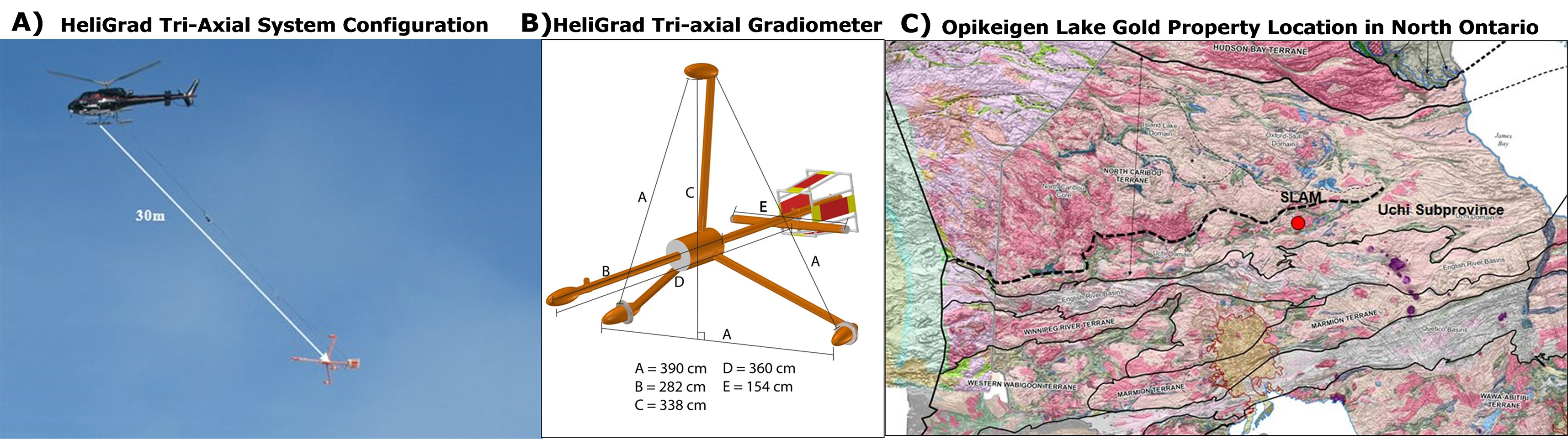
Figure 1: A) HeliGrad tri-axial helicopter magnetic gradiometer system. B) HeliGrad tri-axial gradiometer configuration and dimensions. C) Opikeigen Lake Gold property location in Uchi Subprovince of Canadian Superior Province,in northern Ontario (courtesy SLAM Exploration Inc.).
Heligrad Tri-Axial Gradiometer System Description
The four magnetometers of the HeliGrad system are mounted on a rigid non-magnetic frame (Figure 1b). As a result, the relative positions of the four sensors remain unchanged. A GPS receiver and a Gyro Inclinometer are mounted on the platform to monitor its position and orientation at all time. The gradiometer can pitch drastically during climb and flying into a head wind. Of course it can swing from side to side as well in windy conditions. In order to provide true gradients along the ideal in-line, cross-line and vertical directions, tilt corrections must be applied to the magnetic data collected.
Magnetic and Heligrad Tri-Axial Gradiometer Data Corrections
The magnetic data collected from the HeliGrad gradiometer system are corrected for spikes and diurnal variations. No lag correction is needed for magnetic data, since the position of the platform or bird GPS receiver is used as the data coordinate. However, some special corrections pertinent to gradiometer systems only must be applied to the data collected from the HeliGrad.
Since the HeliGrad gradiometer system is mounted on a rigid frame, the sensors positions are fixed with respect to each other. Therefore, one can work with the gradient vectors directly. The corrections applied to the gradient vectors are for the tilts of the platform. Tilts can be decomposed into three cardinal components, i.e. pitch, roll and yaw. The definitions of pitch, roll and yaw are given and illustrated in Figure 2a.
One can calculate gradients from Total Magnetic Intensity (TMI) data collected using a single magnetometer by 1D FFT for in-line and vertical gradients and 2D FFT for cross-line gradient. Under normal circumstances, the calculated in-line and vertical gradients are fairly comparable to the measured ones, except for very active magnetic areas. However, for cross-line gradient, the calculated is much inferior to the measured (Figure 2b). In general, for magnetic gradients, one can say that the measured are always better.
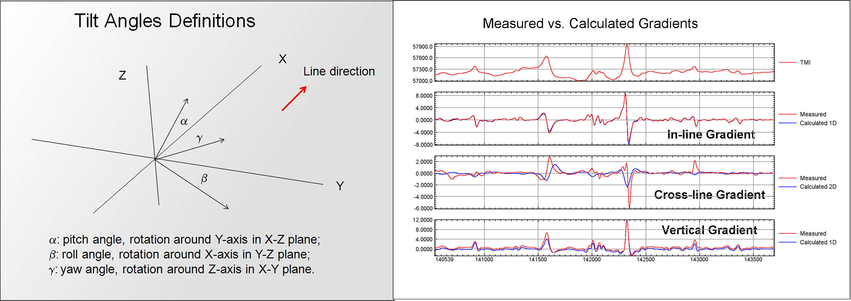
Figure 2: A) Definitions of Pitch, Roll and Yaw; B) Comparison of Measured and Calculated Gradients, from HeliGrad system data
Field Survey Case Study Using The Heligrad Tri-Axial Gradiometer System
The Opikeigen Lake Gold Property is jointly owned by SLAM and Beatrix Ventures Inc. It is situated 10 km northwest of Fort Hope, Ontario. The property is located within the Uchi Subprovince, Superior Province of the Canadian Shield (Figure 1c; Stott 2010). The Uchi Subprovince is a 600-kilometre long greenstone belt, extending from Ontario-Manitoba border to the Hudson Bay Lowlands, hosting the Pickle Lake and the very productive Red Lake gold camps (Technical Report, 2009). It is underlain by volcanic and sedimentary rocks. High grade gold mineralization is associated with quartz veins in sheared and altered mafic volcanics in contact with the sediments.
In the Opikeigen Lake area, the greenstone belt is composed of east trending, isoclinally folded sequence of metavolcanic and metasedimentary rocks, Figure 6. The sediments are overlain by a basal sequence of felsic volcaniclastics and an upper sequence of mafic flows with intervals of sediments including iron formation.
Contacts between the metavolcanics and metasediments and structural traps along faults or shear zones are places to search for gold deposits. The magnetic gradient data collected using the HeliGrad system can help to find those places.
The lithological contacts between the metavolcanics and metasediments, and zones of metavolcanics (Vf and Vm) and metasediments (Sm) are inferred from the Total Magnetic Intensity (TMI) data, in Figure 3a. Lithological contacts usually track the local maxima of magnetic gradients. Zones of metavolcanics possess moderate to strong magnetic values, while the zones of metasediments exhibit low, especially the background, magnetic values. Zones of Band Iron Formations (BIF) are outlined as well. BIF have very strong magnetic responses.
Lineaments and faults are inferred from the tilt derivatives (Salem, 2008) computed directly from the measured magnetic gradients, in Figure 3b. Clearly shown are the SW-NE faults or shears cutting across the east trending sequences of metavolcanics and metasediments. The prospective zones of gold deposits are places where the faults intersect with the contacts, Figure 3c. It is quite clear that most of the interpreted gold prospective zones coincide with the known gold showing in the area.
The usefulness of the magnetic data in mineral exploration, as demonstrated in Opikeigen Gold project, is without question. The magnetic gradients data collected by HeliGrad tri-axial gradiometer system provide a sound geophysical basis for geological mapping and structural interpretations.
Conclusions
The helicopter-borne full Tri-axial magnetic gradiometer (HeliGrad) system provides measured and tilt corrected gradient data in in-line, cross-line and vertical directions. The magnetic gradients data collected by the HeliGrad system can be used in geological mapping and structural interpretations. Tilt-angle derivatives, which use all the measured gradients, are very useful in delineating lineaments and faults, as demonstrated in the Opikeigen Gold Project, SLAM Exploration Inc.
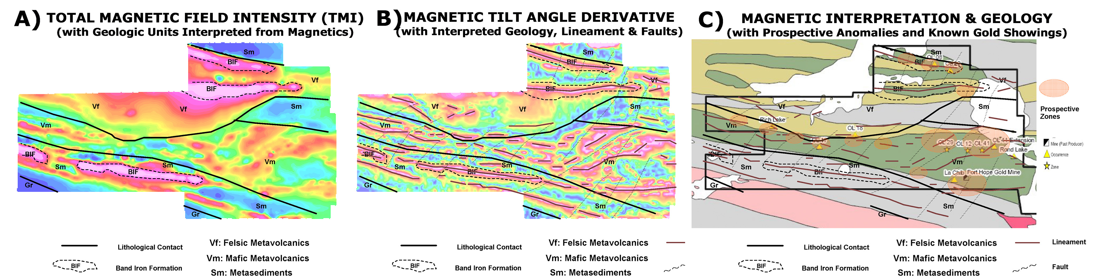
Figure 3: A) Lithologic units inferred from Total magnetic Intensity (TMI) data (B) Interpreted geology, lineaments & faults over derived magnetic tilt-angle derivative; C) Interpreted prospective zones from magnetics over known geology, featuring gold occurrences.