Presented at AEG 2015, India
For a PDF of this paper click here
Summary
In 2008 Geotech flew a regional scale 24,675 line-km survey covering a 25,000 km2 area (1 km line spacing) in the Selwyn Basin. The survey footprint straddles east-central Yukon and overlaps into the western Northwest Territories. In March 2013 Yukon Geological Survey purchased the survey data, and in November 2013, released the data publicly. The Selwyn Basin area is prospective for SEDEX-style Pb-Zn-Ag mineralization and the ZTEM survey data provide insights into regional structures and plutons in the region. The Howard’s Pass SEDEX deposits at the southeastern edge of the Selwyn Basin survey area host a ~250 million tonne resource with ~4.5% Zn and ~1.5% Pb.
Major NW-SE to ESE and minor NNW-SSE linear conductive trends correlate with known regional geologic, structural and inferred mineral trends that were not visible in magnetic results. Circular conductive anomalies surrounding resistivity highs reflect po-rich contact-metamorphic hornfels above/around intrusive plutons also seen in aeromagnetics. 2D-3D computer inversions reveal a correlation between enhanced conductivity along strike and the clustering of deposits at Howard’s Pass.
Key words: Airborne, ZTEM, electromagnetics, magnetics, 2D-3D inversion, Selwyn Basin, SEDEX.
Introduction
The Selwyn Basin, which extends from Alaska to northern British Columbia (Figure 1), is considered one of the most productive Zn-Pb-Ag sedimentary exhalative (SEDEX) regions in the world, with more than a dozen major dozen deposits identified. The SEDEX deposits at Macmillan Pass and Howard’s Pass in east-central Yukon (Fig. 1) are believed to have the highest potential for development (Goodfellow, 2007). Howard’s Pass, in particular, is world class, with an estimated mineral potential of ~250M tonnes at 4-5% zinc and 1-2 % lead contained in 15 separate deposits that extend over a 37.5 km strike length (Kirkham et al., 2012). The Howard’s Pass deposit is owned by Chihong Canada Mining Ltd. (Vancouver, CAN) and is currently in pre-development (www.chihong mining.ca). This study presents the results from a large regional EM survey over flown in 2008 (Witherly, 2013) with the ZTEM (z-axis tipper electromagnetic) helicopter EM and magnetic system (Lo and Zang., 2008) that covers a >20,000 km2 area of the Selwyn Basin, approximately 80km northeast of Ross River, Yukon (Fig. 2) and will focus on the Howard’s Pass SEDEX deposit responses.
Although EM is credited with the discovery of the Clear Lake SEDEX in central Selwyn Basin, stream and seep geochemistry, lithogeochemistry, mapping and prospecting, along with drilling are primarily used in the region (Goodfellow, 2007).
Airborne geophysics has not been extensively used in SEDEX exploration of the Selwyn Basin, due to the lack of magnetic contrasts and similar conductivities of ores to the host black shales (Goodfellow, 2007; Witherly, 2014). Ground geophys-ics including magnetic, EM, SP, gravity, VLF and resistivity have been used at Howards Pass, but have proven ineffective at defining/discriminating the mineralized SEDEX horizons. However gravity and resistivity in particular were able to define stratigraphy under areas of cover (Burgoyne, 2005). Indeed the 2008 ZTEM survey of eastern Selwyn Basin (Figure 2) was commissioned by Exploration Syndicate Inc. (ESI) to map regional lithologies and structures related to SEDEX deposits below thick overburden and sedimentary cover, based on resistivity contrasts (M. Zang, ESI, pers. comm., 2008).
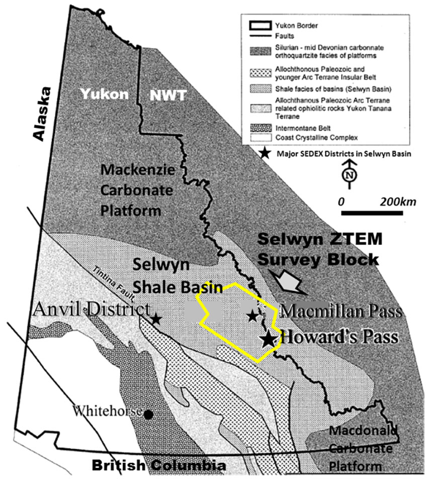
Figure 1. Regional geology of Yukon, showing outline of ZTEM survey block (yellow) and SEDEX districts in Selwyn Basin (modified after Burgoyne, 2005).
While the SEDEX deposits in Selwyn Basin were initially discovered in the early 1950’s to late 1970’s (Goodfellow, 2007) and extensively explored since then (Witherly, 2014) airborne geophysical coverage in the Selwyn Basin is limited, with only a regional magnetic survey by the Geological Survey of Canada publically available. The 2008 Selwyn Basin ZTEM survey, recently purchased by the Yukon Geological Survey (McFarlane and Nordling, 2014) is one of the few available airborne AFMAG EM-magnetic data sets (i.e., Mt. Milligan; Steffer et al., 2009) and also covers a variety of SEDEX and other types of mineral deposits (Carne et al., 2013), as shown in Figure 2. Legault et al. (2013) have also presented ZTEM passive EM and VTEM time-domain EM and magnetic survey results over the Nuqrah Cu-Pb-Zn-Ag SEDEX deposit in Saudi Arabia.
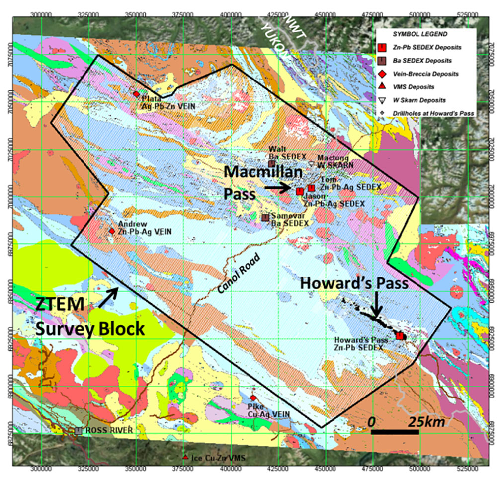
Figure 2. ZTEM survey block (black) and flight lines (white) over Selwyn Basin geology (Gordey and Makepiece, 1999) showing mineral deposits (after Lewis, 2009) and drillholes at Howard’s Pass.
Geology and Mineralization
The Selwyn Basin is a northwest trending Paleozoic deep water sedimentary basin mainly composed of black shales and cherts that host SEDEX and stratiform barite deposits (Figure 1-2). The Selwyn basinal sediments are bounded to the west by the Tintina Fault and to the east, north and south by the Mackenzie and Macdonald carbonate platforms (see Fig. 1) that also host Mississippi Valley-type (MVT) deposits. The basin is unconformably underlain by Hadrynian-Cambrian-age basement grit rocks that form part of the continental margin. The Selwyn Basin consists of a lower section of Early Ordivi-cian to Early Devonian mudstones, siltstones, carbonates, chert and minor sandstone. The upper section consists of Devonian to Mississippian and Early Triassic mudstones and siltstones, with more abundant sandstones and conglomerates. The Selwyn Basin rocks were weakly deformed and metamor-phosed during the Mesozoic and are now present as thrust-sheets. Except for fold and thrust deformation and metamor-phism to greenschist, the Selwyn Basin is relatively well pre-served (ref. Burgoyne, 2005; Goodfellow, 2007; Kirkham et al., 2012).
The three SEDEX base metal districts that occur in the Selwyn Basin of Yukon (Anvil, Macmillan Pass and Howard’s Pass – Fig. 1) are related to major episodes of mafic volcanism. SEDEX deposits occur in fault-bounded grabens and formed in reduced sulphur-rich settings from hydrothermal vents located along extensional faults. Unlike vent-proximal SEDEX deposits (i.e., Macmillan Pass, Anvil), which are mound-shaped, laterally zoned and rapidly change in thickness, vent-distal deposits (i.e., Howard’s Pass) are more uniform in thickness, more widespread and not strongly zoned. Except for stratiform barite, the other mineral deposits in the Selwyn Basin (see Fig. 2) postdate its deposition and are related to Mesozoic and Cenozoic tectonic and related intrusive events (Goodfellow, 2007).
The Late Cambrian deposits of the Anvil District near Faro that lie west of the ZTEM survey area (see Fig. 1) have been the only SEDEX deposits exploited to date but are currently inactive. The Late Devonian age Tom and Jason deposits at Macmillan Pass (see Fig. 2) feature higher grades of Pb-Zn-Ag but lowest tonnages (6.43 Mt indicated @ 6.33% Zn, 5.05% Pb & 56.66 g/t Ag) and have never been developed. The Early Silurian SEDEX deposits at Howards Pass consist of 14-15 separate orebodies with combined world-class tonnages but relatively low grade (181 Mt indicated @ 5.25% Zn & 1.83% Pb) that were, until recently, considered subeconomic (ref. Goodfellow, 2007; Rennie, 2007; Kirkham et al., 2012).
The Howard’s Pass SEDEX deposits were discovered in 1972 using regional stream sampling for lead-zinc. Extensive soil sampling, trenching, mapping and drilling continue to guide exploration. The local geology in Howards Pass consists of Hadrynian to Cambrian basement phyllites and coarse clastics units that outcrop to the southeast of the property. These are followed by a thick sequence of Cambrian-Ordivician age Rabbitkettle limestones and calcareous mudstones. These are overlain by the Ordivician to Silurian Road River Group black shales that consist of Howard’s Pass Fm carbonaceous mud-stones at the base, and flaggy and siliceous mudstones at the top. The Howard’s Pass Fm. includes the sulphide-rich Active Member unit that contains all the known zinc and lead mineralization at Howard’s Pass (see Fig. 3). The Road River Group is overlain by Devonian to Mississippian Lower and Upper Earn Group mudstones. The rocks have been intruded locally by Cretaceous felsic intrusions. The geology can be structurally complex, with the deposits to the southeast lie on the south limb of a large ~N-300O trending regional syncline, whereas to the northwest they lie on a steeply dipping, NW-trending contact, as shown in Figure 3b (Burgoyne, 2005; O’Donnell, 2009; Kirkham et al., 2012).
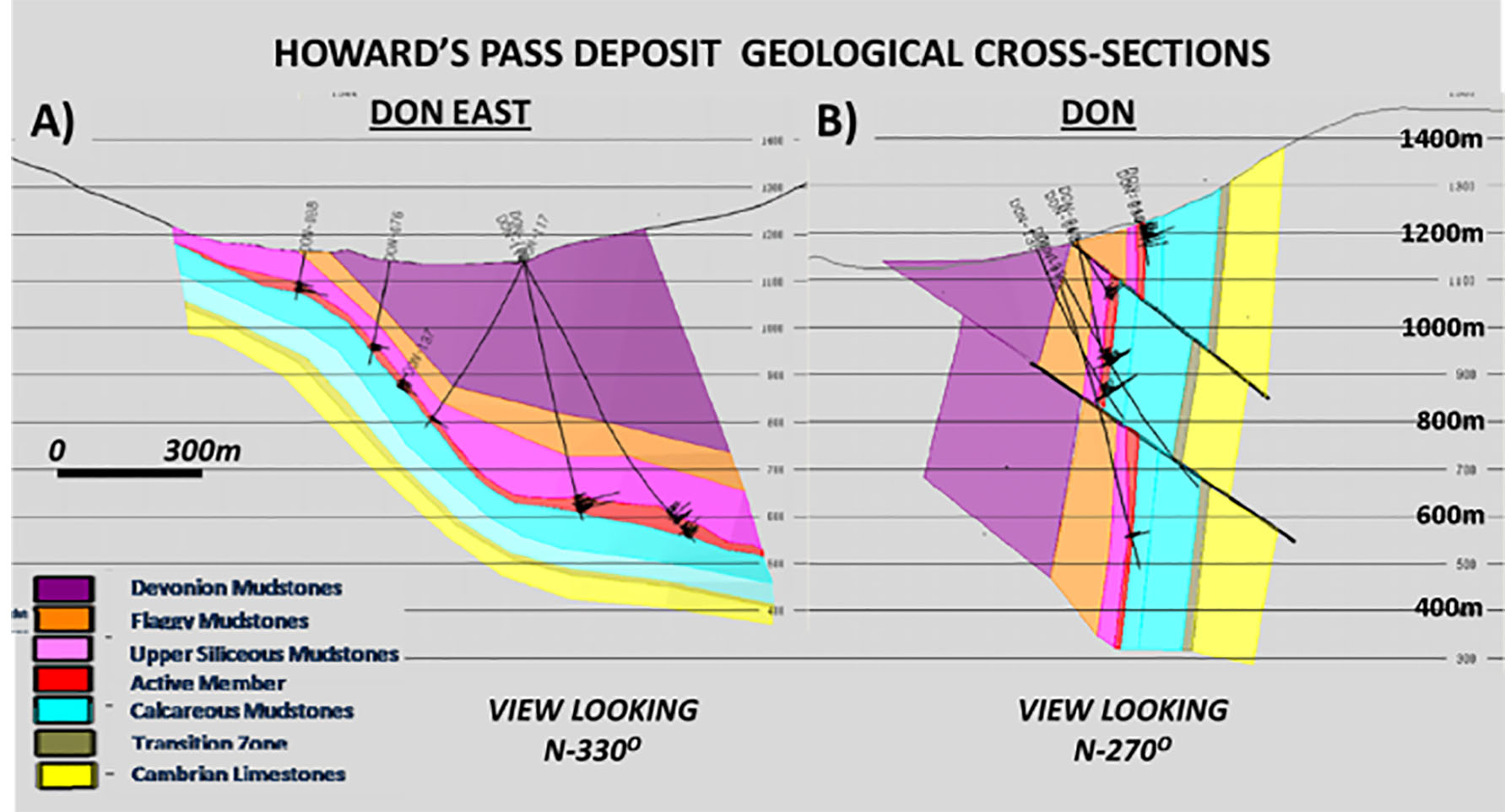
Figure 3. Howard’s Pass geological cross-sections at Don East (A) and Don deposits (B), showing complex structure, drillholes, and geologic units across HP valley (modified after O’Donnell, 2009).
The mineralized horizon at Howard’s Pass, referred to as the “zinc corridor”, trends NW-SE and extends for 37.5km, with the 15 drilled deposits and zones offset/separated by interpreted faults. The Active Member is generally 20-30m thick and consists of laminated, fine-grained sphalerite and galena with minor pyrite. Higher grade zones, like XY Central (45.11 Mt indicated @ 5.17% Zn & 2.49% Pb) and Don (36.90 Mt indi-cated @ 5.63% Zn & 2.11% Pb), are coarser grained, exhibit sulphide-remobilization, contain multiple lenses and occur near the base of the Active Member (Goodfellow, 2007; Kirkham et al., 2012).
Passive AEM and Magnetic Results
The ZTEM passive AFMAG (Labson et al., 1985) helicopter EM and aeromagnetic survey at Selwyn Basin was flown between May to October, 2008 (Witherly, 2013). It consisted of 24,675 line-kilometres of coverage using 1000 line-spacings and 500m in-fills along N-035O oriented survey lines (Fig. 2). ZTEM tipper data (Tzx in-line & Tzy cross-line) were acquired at 5 frequencies (30-360Hz). Readers can refer to Legault et al., (2012) for additional descriptions of the ZTEM system and theory.
Regional Survey Results
The regional ZTEM and magnetic results in Selwyn Basin were presented by Carne et al. (2013) and Witherly (2014). The reduced-to-pole (RTP) image of the residual (IGRF-corrected) total magnetic intensity (TMI) in Figure 4 highlights magnetic high signatures from Cretaceous monzonitic-granitic intrusions; which, in spite of their low magnetic susceptibility, cause magnetic hornfels in surrounding rocks from related contact metamorphic pyrrhotite (Moynihan, 2013; Carne et al., 2013). Except for the SEDEX deposits, which are not visibly magnetic to due lack of ferromagnetic minerals (Goodfellow, 2007), most of the known vein-breccia and skarn deposits and occurrences are associated with the intrusive-related magnetic highs (Carne et al., 2013; Witherly, 2014).
Figure 5 presents the total divergence (DT) image of the ZTEM In-phase tipper at 90Hz. The DT that is analogous to the VLF peaker of Pedersen (1998) converts tipper cross-overs into peak-responses (Lo and Zang, 2008). The DT image highlights resistive (blue) and conductive (red) signatures, in particular the circular anomalies associated with igneous intrusions and the surrounding magnetic and po-rich metamorphic aureoles. More importantly the many prominent NW-SE trending and secondary NNW-SSE conductive and resistive lineaments are defined that relate to both shale-rich and siliceous or carbonate-rich sedimentary units, as well as porous fault-fracture zones, which were not visible in the magnetic results. These include very well defined lineaments over Howard’s Pass, as shown in Figures 5-6. Carne et al. (2013) and Witherly (2014) also point out the relationship between these conductive lineaments that form 10-20km wide trends along which the majority of significant mineral deposits, showings and prospects in Selwyn Basin are situated.
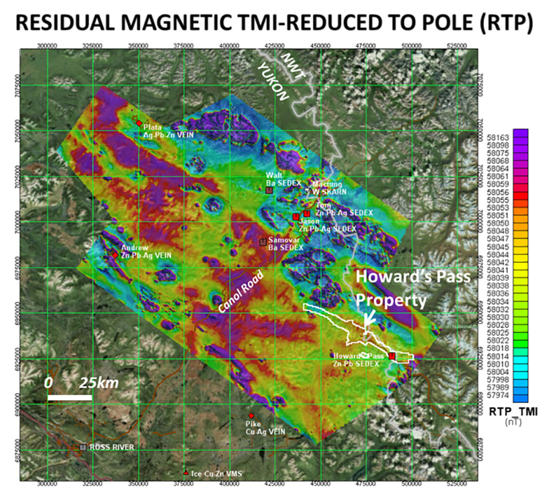
Figure 4. Residual magnetic TMI reduced to pole (RTP), highlighting magnetic highs over Cretaceous intrusions, with mineral deposits and HP property outline.
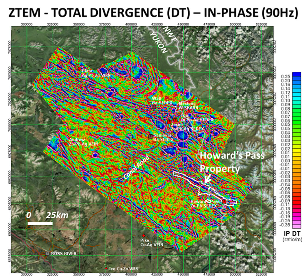
Figure 5. ZTEM total divergence (DT) for 90Hz In-phase component, highlighting low (blue) and high (red) resistivi-ty features over intrusions, stratigraphy and other geology.
Howard’s Pass Survey Results
The ZTEM total divergence image from Figure 5 is shown over a smaller 70x80km area that focuses on the Howard’s Pass SEDEX region in Figure 6. It highlights a thin, NW-SE trending conductive lineament that extends through the >37km long “zinc-corridor” deposit area as defined by drilling. Each of the 15 known SEDEX deposits, defined by ddh clusters and labelled by name (ref. Kirkham et al., 2012), overlie the How-ard’s Pass (HP) ZTEM conductor. Because the mineralized Active Member is thin (<30m), the HP conductor must also encompass the surrounding Howard’s Pass Fm. black shales units to be resolvable in the AEM results. As shown, the HP ZTEM conductor flanks the southwest edge of a broader, 1-2km wide, high resistivity unit (carbonates), that is in turn flanked by another thin conductive lineament (barren shale units) on its north-eastern edge. The conductive band that hosts HP is the most prominent in the area and extends for ~70km – pinching to the northwest, just outside the focus area, and terminating to the SE where basement rocks outcrop (ref., Gordey and Makepiece, 1999).
Figure 7 presents a resistivity-depth slice at 300m obtained from 2D ZTEM inversions (ref. Legault et al., 2012) across a 35x50km model region that is centred on the Howards Pass SEDEX deposits. It shows a narrower, slightly less uniform and more variably conductive trend along Howard’s Pass de-posit area than previously seen in the raw ZTEM data images. Interestingly, most of the deposits appear to be grouped/ clus-tered within areas of higher conductivity along strike (see Fig. 7), in particular the larger tonnage deposits at Anniv, Don-Don East and XY. Similar on-strike conductivity variations are observed in the 3D inversion (not shown) obtained using UBC MT3dinv code (ref. Holtham and Oldenburg, 2008). This suggests possible enhanced mineralization in areas of thicker black shale sub-basins that are being defined with AEM. Alternately, this might simply reflect separation of the mineralized and shale horizons by fault-displacement. Both inversions show better strike continuity at greater depths (>500m).
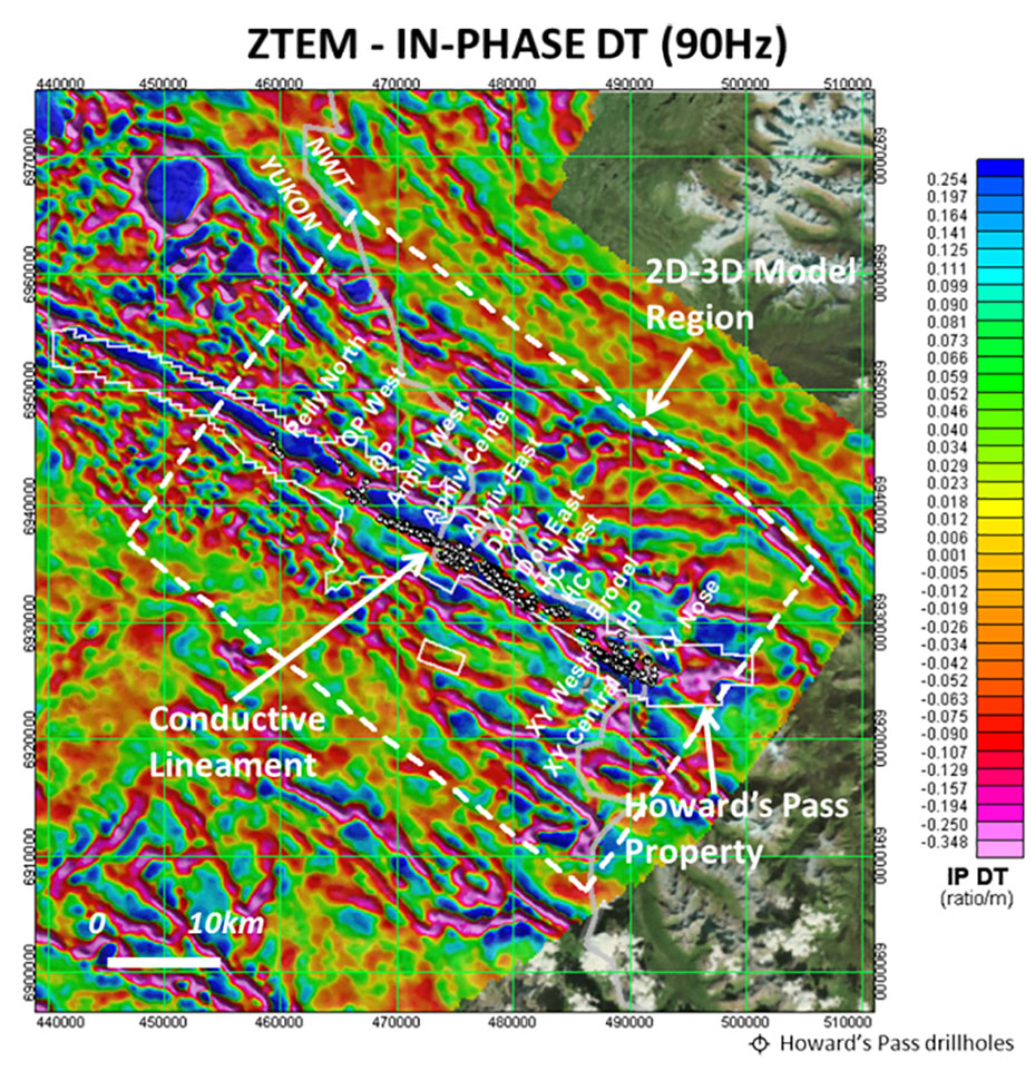
Figure 6. ZTEM 90Hz In-phase DT, over focus area at Howard’s Pass, highlighting conductive lineament and HP drillholes, known deposits and 2D-3D model region dis-cussed below.
Figure 8 compares a similar magnetic susceptibility (mag-susc.) depth-slice, obtained using UBC Mag3d (Li and Oldenburg, 1996), as the ZTEM resistivity image shown in Figure 7. It shows generally low mag-susc. values across the HP property which is consistent with the sedimentary host rocks. However a weak but well defined magnetic high is also seen that correlates with the south-eastern half of the HP deposit trend and ZTEM conductive zone and strengthens at depth. Closer examination reveals that it coincides with the southeast part of the deposit that lies in the valley at Howard’ Pass. This might be explained by enhanced hydrothermal activity and/or basement uplift along the HP mineralized horizon; or else, simply, slightly more susceptible pelitic and mineralized units that are exposed in the valley in contrast with very low susceptibility carbonates found in the surrounding hills.

Figure 7. ZTEM Resistivity depth-slice (z=300m) from 2D Inversion (Tzx In-line) over detailed grid at Howard’s Pass, highlighting conductive lineament over deposits and location of L4730 model section in Fig. 9.
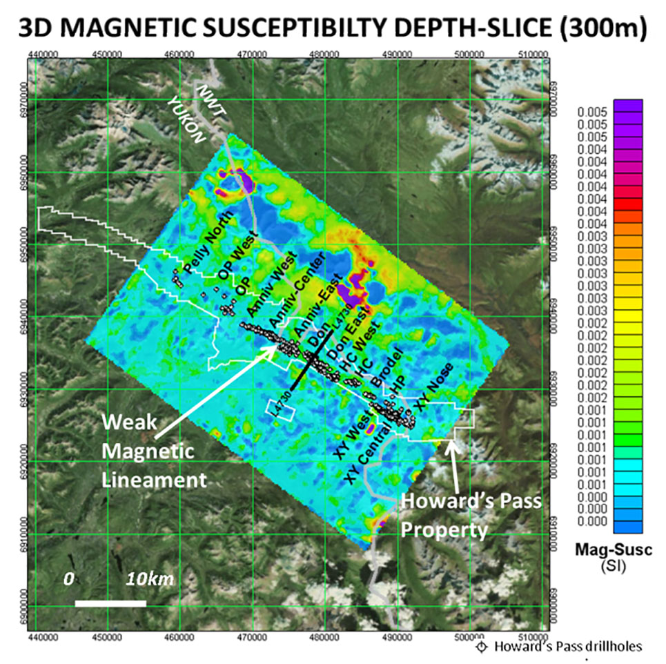
Figure 8. Magnetic susceptibility depth-slice (z=300m) from UBC 3D Inversion over detailed grid at Howard’s Pass, highlighting weak magnetic lineament over deposits and location of L4730 model section in Fig. 9.
Figure 9 compares the 3D ZTEM resistivity and 3D mag-susc. sections over the Don deposit, one of the largest and more deeply explored at Howard’s Pass, with many drillholes extending below 800m depths, as shown in Figure 3. Figure 9a highlights the shallow buried but >500m wide resistivity low that matches the known width of the Don deposit and extends to similar depths. Resistivity highs on either side coincide with flanking carbonate units. Figure 9b shows a buried, weak but visible mag-susc. high that correlates with the deposit and extends to depth. Higher mag-susc. values at 1.5-2km depth likely reflect the deeper basement metamorphic units.
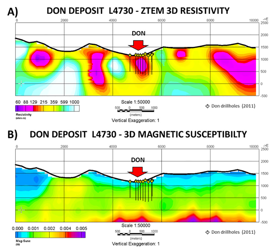
Figure 9. Don Deposit L4730: A) ZTEM UBC 3D resistivi-ty cross-section and B) UBC 3D Magnetic Susceptibility sections, with 2011 drillholes, showing high conductivity and slightly higher magnetic susceptibilities across deposit.
Conclusions
Regional ZTEM and magnetic survey data over a 23,000 km2 area of Selwyn Basin reveal major NW-SE to ESE and minor NNW-SSE linear conductive trends that correlate with known regional geologic, structural and inferred mineral trends. These were not readily defined in magnetic survey results owing to lack of magnetic susceptibility contrasts in the sedimentary host rocks. In addition, circular conductive anomalies surrounding resistivity highs reflect po-rich contact-metamorphic hornfels above/around intrusive plutons that are also defined in the regional magnetic results. The ZTEM and magnetic results at Howard’s Pass SEDEX district have been analysed at the property and deposit scale using 2D-3D computer inversion to better define their relation to geology. Their study appears to reveal a correlation between enhanced conductivity along strike and the clustering of deposits at Howard’s Pass. This could be explained either by enhanced mineralization in areas of thicker black shale sub-basins or simply separation of the mineralized and shale horizons by fault-displacement.
Acknowledgements
This paper stems from the YGS airborne geophysics workshop in Whitehorse, organized by Yukon Geological Survey and Ken Witherly and Condor Consulting in Nov-2013. We wish to also acknowledge Rob Carne and Archer-Cathro for their geologic synthesis of the Selwyn ZTEM that influenced this study.
References
Burgoyne, A.A., 2005, Technical evaluation report on The Howards Pass Project, Yukon-Northwest Territory border, Canada: Report (NI 43-101) for Pacifica Resources Ltd., 81 p.
Carne, R., Phillips, R., and Lane, J., 2013, An explorer’s take on the Selwyn Basin ZTEM survey: Presented at Yukon air-borne geophysics workshop, Yukon Geoscience Forum 2013, Yukon Chamber of Mines and Yukon Geological Survey, Whitehorse, Canada.
Goodfellow, W.D., 2007, Base metal metallogeny of the Selwyn Basin, Canada, in Goodfellow, W.D., ed., Mineral Deposits of Canada: A Synthesis of Major Deposit-Types, District Metallogeny, the Evolution of Geological Provinces, and Exploration Methods: Geological Association of Canada, Mineral Deposits Division, Special Publication 5, 553-579.
Gordey, S.P. and Makepeace, A.J. (compilers), 1999, Yukon digital geology: Geological Survey of Canada Open File D3826, 1:250,000 scale.
Holtham, E., and Oldenburg, D.W., 2008, Three-dimensional forward model and inversion of Z-TEM data: SEG, Expanded Abstracts, 564-568.
Kirkham, G., Dunning, J., and Schleiss, W., 2012, Update for Don Deposit mineral resource estimate, Howard’s Pass prop-erty, eastern Yukon: NI 43-101 technical report for Selwyn Resources Ltd., 145 p.
Labson, V. F., A. Becker, H.F. Morrison, and U. Conti, 1985.
Geophysical exploration with audio-frequency natural magnetic fields: Geophysics, 50, 656–664.
Legault, J.M., Wilson G., Gribenko A., Zhdanov, M. S., Zhao, S. and Fisk, K., 2012, An overview of the ZTEM and AirMt airborne electromagnetic systems – A case study from the Nebo-Babel Ni-Cu-PGE deposit, West Musgrave, Western Australia: Preview, 158, 26-32.
Legault, J.M., Prikhodko, A., Izarra, C., Zhao, S., Saadawi, E.M., 2013, Helicopter EM (ZTEM-VTEM) survey results over the Nuqrah Cu-Pb-Zn-Au SEDEX massive sulphide de-posit in the Western Arabian Shield: ASEG, Extended Ab-stracts, 4 p.
Lewis, L. (compiler), 2009. Yukon Mineral Deposits Summary 2009: Yukon Geological Survey, 14 p.
Li, Y., and Oldenburg, D.W., 1996, 3-D inversion of magnetic data, Geophysics, 61, 394-408.
Lo, B., and Zang, M., 2008, Numerical modeling of Z-TEM (airborne AFMAG) responses to guide exploration strategies, SEG, Expanded Abstracts, 27, 1098-1101.
MacFarlane, K.E., and Nordling, M.G., 2014, Yukon Exploration and Geology Overview 2013: Yukon Geological Survey, Energy, Mines and Resources, 80 p.
Moynihan, D., 2013, An introduction to the geology, tectonics and metallogeny of the Selwyn Basin area: Presented at Yukon airborne geophysics workshop, Yukon Geoscience Forum 2013, Yukon Chamber of Mines and Yukon Geological Survey, Whitehorse, Canada.
O’Donnell, J., 2009, Resource estimate report update for the Selwyn Project, Yukon-NWT, Canada: Technical report (NI 43-101) prepared for Selwyn Resources Ltd., 132 p.
Pedersen, L.B, 1998, Tensor VLF measurements: Our first experiences: Exploration Geophysics, 29, 52-57.
Rennie, D.W., 2007, Technical report on the Tom and Jason deposits, Yukon Territory, Canada: (NI 43-101) report prepared for Hudbay Minerals Inc., by Scott Wilson Roscoe Postle Associates Inc., 202 p.
Steffler, E., Legault, J., and Milicevic, B., 2009, Helicopter borne Z-axis tipper electromagnetic (ZTEM) and aeromagnetic survey, Mt. Milligan test block: Final report for Geoscience BC Project 2008-032 by Geotech Ltd., Geoscience BC report 2009-7, 75 p.
Witherly, K., 2013, Report on processing of ZTEM magnetic and EM surveys, Selwyn basin area, Yukon, Canada: Yukon Geological Survey miscellaneous report MR-9, 49 p.
Witherly, K, 2014, Regional airborne geophysical assessment of the Selwyn Basin area, Yukon-NWT: Presented at PDAC Prospectors and Developers Convention, Geophysics Session, Toronto, Canada.